
Projects
Current Projects
Inglewood Bird Sanctuary Migration Monitoring
Neotropical migrants are birds that breed in the Nearctic and winter in the Neotropics. The Neotropical migratory bird system involves some 5-10 billion birds of over 150 species (Greenberg 1992). Trends in data from the Co-operative Breeding Bird Survey indicate that many Neotropical migrants in North America are decreasing. Although destruction of tropical forests on the wintering grounds has been implicated in declines, increasing concern is being raised about the potential effect of accelerated land-use changes on breeding grounds.
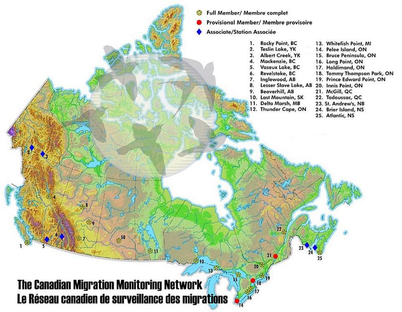
The main objective of CBBS is to conduct migration monitoring and other banding-based studies at Inglewood Bird Sanctuary (IBS), a federal Migratory Bird Sanctuary. IBS has long been known as an important migration site for Neotropical migrants. Located within 80-km of the Rocky Mountains, IBS is an integral component of the Canadian Migration Monitoring Network coordinated and administered by Bird Studies Canada.
Both spring and fall migration of Neotropical migrants is monitored at Inglewood Bird Sanctuary (IBS). IBS’s 35 hectares includes mature riverine balsam poplar forest known for its number and diversity of songbirds during spring and fall migration. Constant-effort mist-netting (i.e. constant number of nets in permanent locations for constant time period each day) and collection of associated morphometric and other data (e.g. age, sex, wing chord, weight, fat reserves, capture net, time of capture) from each bird captured is carried out each day, weather permitting, during spring and fall migration. Twelve 12-m long x 30-mm mesh mist-nets are operated in permanent net lanes for approximately 6-hours each day beginning at sunrise. Mist-netting produces a daily count of new captures for each species from which trends are calculated.
See ATRs (1995 – present) for results and preliminary reports
Monitoring Avian Productivity and Survivorship (MAPS) Program
The Monitoring Avian Productivity and Survivorship (MAPS) Program was created by The Institute for Bird Populations in 1989 to assess and monitor the vital rates and population dynamics of over 120 species of North American landbirds in order to provide critical conservation and management information on their populations. CBBS operates a MAPS site at IBS.
The MAPS Program utilizes constant-effort mist netting and banding at a continent-wide network of monitoring stations staffed by both professional biologists and highly trained volunteers.
North America is divided into eight major regions based on biogeographical and meteorological considerations, and each region has, within it, target species. IBS falls into the Northwest Region whose target species are:
- Dusky Flycatcher
- Western Flycatcher complex
- Swainson’s Thrush
- American Robin
- Warbling Vireo
- Orange-crowned Warbler
- Yellow Warbler
- MacGillivray’s Warbler
- Wilson’s Warbler
- Song Sparrow
- Lincoln’s Sparrow
- “Oregon” Dark-eyed Junco
All of these species have been captured at IBS although only American Robin, Warbling Vireo, Yellow Warbler, Song Sparrow, and Lincoln’s Sparrow are breeders (see table from the latest ATR). MAPS data is provided to the Institute for Bird Populations in Point Reyes, CA where it is integrated with data from the over 500 other North American stations.
Objectives
The overall objective of the MAPS Program is to contribute to an integrated avian population monitoring system for selected North American landbirds. The indices and estimates obtained:
- Determine annual changes and, ultimately, longer-term trends in population and demographic parameters of target species in each region;
- Relate these trends to readily-measured environmental co-variates such as climatic factors, habitat type, and management practice; and
- Refine current population models and develop new ones.
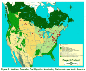
Northern Saw-whet Owl Migration Monitoring
Since 2004, the CBBS has been monitoring migrating Northern Saw-whet Owls (Aegolius acadicus) (NSWO) at a site in the foothills southwest of Calgary ear Bragg Creek. This site has proven itself as a good location for monitoring migration of Northern Saw-whet Owls. Monitoring sites for this species are well established in eastern North America but sparse in western North America.
Monitoring begins mid September and continues through the end of October. A continuous audiolure (recording of NSWO calls) is played to enhance capture rate. It is placed at the center of an array (double H) of five 12-m long x 60-mm mesh mist-nets. The array is beneath a thick canopy of mature spruce trees. The area has been subject to cattle grazing and the understory and tree branches as high as a cow can rub are absent. The audiolure commences approximately 0.5-hrs after sunset and continues for 4-hrs, weather and other factors permitting. Nets are checked at least every 0.75-hrs by a Bander-in-Charge (BIC) and 1 or more volunteers. Sex, age and morphometric data are collected on all owls captured. Basic weather data (wind direction and speed, sky conditions and temperature) is noted at start and finish each evening.
See ATRs (2004 – 2008 and 2010 – present) and preliminary reports
TREES, Belize Spring Migration Monitoring
It is the view of CBBS that spring migration monitoring of Neotropical migrant landbirds is best done close to the wintering grounds. With that in mind CBBSA continued its quest for a suitable site in Belize after unsuccessful attempts to establish stations in Costa Rica (Las Caletas and La Selva) and Mexico (Minatitlan). During 2015 and 2016 pilot spring migration monitoring was undertaken at Toucan Ridge Ecology and Education Society, Belize (TREES). Based on encouraging results standardized spring migration monitoring was initiated in 2017 from 29 March to 10 May and is ongoing.
Completed Projects
Northern Saw-whet Owl Migration Monitoring Pilot Project
Dunbow Road Project 1997 – 1999
Cominco Natural Area 2000 and 2001
Dinosaur Provincial Park, Pilot MAPS Project
Ranger Creek, Banff National Park Pilot Project
Colour-Banding and Relocation of Red-tailed Hawks and Swainson’s Hawks
Costa Rica Projects 2002 – 2012
Migration Monitoring in La Selva
MoSI (Monitoreo De Sobrevivencia Invernal)
Stable Isotope Ecology 2004 – 2008
Completed Projects
Northern Saw-whet Owl Migration Monitoring Pilot Project at Inglewood Bird Sanctuary 2000
Methods
Local records, both sightings and recovered specimens indicated that October was the peak window for migrating Northern Saw-whet owls. Monitoring was begun at Inglewood Bird Sanctuary (IBS)16 September and continued through 7 November. A continuous recording of “Northern Saw-whet Owl” call played at maximum volume on a portable “ghetto-blaster” from the centre of a triangle of mist-nets. The triangle was located just west of the Colonel Walker House and consisted of two 12-m x36-mm net positioned at right angles to each other against the Caragana hedge and the line of poplar trees. An 18-m X 60-mm net was positioned along the hypotenuse of the triangle formed by the two 36-mm nets. Tape playback commenced approximately 0.5hrs after sunset and continued for 4-hrs. weather and other factors permitting. Nets were checked every 0.75-hrs by a Bander-in-Charge (BIC) and 1-2 volunteers. Sex, age and morph metric data were collected on all owls captured. Basic weather data (wind direction and speed, sky conditions and temperature), were noted at start and finish each evening.
Results
Monitoring was carried out on 38 (72%) of the 53 evenings between 16 September and 7 November. No BIC was available for 9 nights and a film crew was active at the monitoring site for 5 nights and one night was lost due to weather. Three Northern Saw-whet owls were captured within a short window from 12-21 October. All were SY with two sexed as females and one as unknown. One bird was caught at 21:00 hrs while the other two were captured at 23:00 hrs. All three were in the lower 1-2 panels of the mist-nets and each of the three mist-nets caught one owl. Weather conditions on the capture evenings were consistently calm but 2 of 3 birds were caught when the moon was full while the other bird was captured during a new moon. Temperatures ranged from +10 to -2 Celsius. Weights of the three owls were 85, 96 and 107 grams.
Discussion
Inglewood Bird Sanctuary is situated in the center of a large city. Although the Bow River offers some habitat to migrating Northern Saw-whet Owls, it is not a continuous vegetated corridor. Our results suggest that there is a Northern Saw-whet Owl movement occurring during fall but that not many owls pass through IBS. A monitoring site outside the city in an area of more continuous and connected forest habitat might yield significantly higher numbers of owls.
Dunbow Road Project 1997 – 1999
The CBBS initiated a spring banding project in 1997 on private property 22-km SSE of the City of Calgary, approximately 1.5 km South of the Bow River that became known as Dunbow Road.
The sampled habitat on the property was comprised of 3 different vegetation types. The first area was a balsam poplar ravine with a predominately willow understory. Spring melt water from the surrounding area flowed north through this area into a small pond before spilling out and flowing into the Bow River. The second area was comprised of two parallel Caragana hedges and a third area was a scrubby aspen forest with a thick red-osier dogwood understory. Five 30-mm mist-nets were located in each of the three habitat types for a total of 15 nets. The site protocol followed that prescribed for all fall migration monitoring at IBS.
During 1998, a banding effort of 304.5 net-hours resulted in a total of 288 captures comprised of 161 new bandings, 110 recaptured, 17 escapes and 3 mortalities.
Banding effort during 1999 totaled 1, 596 net-hours resulting in a total of 405 captures comprised of 245 new bandings, 137 recaptures, (92 repeats and 45 returns), 21 escapes and 2 mortalities. Fifteen individuals of 7 species banded in 1997 were recaptured during 1999. Fifteen individuals of 8 species banded during 1998 were recaptured during 1999.
This station was operated for three years (1997, 1998, 1999).
Migration Monitoring at Cominco Natural Area 2000 and 2001
CBBS was granted permission to monitor migration at a site along the Bow River approximately 5-km south of IBS in 2000. Both spring and fall migration were monitored in 2000. During 2001, only spring was monitored. Fall was not monitored due to a lack of resources, particularly BICs although banding did occur during a short period during fall on an opportunistic basis.
Study Site
The Cominco Natural Area (CNA) is the eastern portion of an approximately 136-ha property owned at that time by Cominco Ltd., which bought the chemical fertilizer plant and lands in 1946. Deerfoot Trail now separates the riverside CNA from the larger former industrial site. The CNA’s other boundaries were Heritage Drive to the north, the Bow River to the east and Southland Park to the south.
There were five major habitat types in the area: aquatic and marginal aquatic habitats; grasslands; disturbed areas; shrub communities; and Balsam Poplar and Aspen woods. The health of these habitats was related to the amount of their use by the resident population of White-tailed deer. The shrub communities were primarily large patches of Chokecherry and Saskatoon that had no branches near the ground and large old willow. Red-osier dogwood, a favorite browse of deer, was abundant across the river and upstream in other city parks and natural areas but virtually absent at this site.
The two large cattail marshes attracted large numbers of Red-winged Blackbirds, Song Sparrows and ducks. American Robins fed in the disturbed areas. Grassy areas, that included patches of Western snowberry and Wild rose supported Clay-coloured and Savannah Sparrows. Large Chokecherry and Willow shrubs were ideal for Cedar Waxwing and House Wren nests. Treed areas attracted flocks of migrating warblers and Common Grackles during fall. It appears that about 45%, or 29 of the 65 passerines and near-passerines species were possible or probably nesting species, based on 2000 spring and fall monitoring.
Most of the CNA had been exposed to limited human use for more than 50 years with some major exceptions. A large canal formerly used as a water inlet source for the Cominco plant bisected CNA and completion of Deerfoot Trail in 1982 created a noisy dissection of the area.
A grassy area north of the canal was cut annually in midsummer to reduce the potential fire hazard. Duck nest boxes and goose nest platforms were erected throughout the property.
Methods
Migration monitoring methods used in 2000 and 2001 were similar to those at Inglewood Bird Sanctuary. Constant-effort mist-netting and collection of associated morphometric and other data (e.g. age, sex, wing chord, weight, fat reserves, capture net, time of capture) from each bird captured was carried out on each day, weather permitting. During 2000 spring migration, nine 12-m long x 30-mm mesh mist-nets were operated for approximately 6 hours each day beginning at sunrise. During fall migration, twelve nets were used. In 2001, the original 9 mist-net lanes were retained and three more mist-nets were established closer to the Bow River.
Fatal Light Awareness Program (FLAP) Calgary 1995-1996
Colliding with glass is often fatal for birds. Of the many and varied threats humans pose on our avian friends, this one literally hits close to home. Window “predation” rates high among the list of threats that are often overlooked by man as simply just a cost of doing business. Concerned, the CBBS initiated a research project to determine the number of avian mortalities that occur in the city’s downtown core, especially during the migration periods and:
Species of birds migrate at night using the stars to navigate. When fog or overcast conditions occur the ceiling at which the birds fly is lowered and this can cause fatalities as the birds could hone-in to building lights left on and potentially hit the buildings. (The Fatal Light Awareness Program (FLAP) in Toronto records over 2000 birds annually).
Since there was not much existing information about this problem in the Calgary area, all information was new and complied for a five-year period to determine fluctuations.
The study sought the cooperation of the larger buildings in the downtown core. The location covered the entire stretch from the Nova Building on the west end to Petro Canada centre on the east end. CBBS asked that the building services (staff) call us with any information on any birds that they may find dead or alive (most building staff are cleaning the sidewalks as we are waking up). Additionally, visual reconnaissance through the downtown area were undertaken by CBBS volunteers on selected days, particularly on overcast days or during major weather events.
Data gathered summarizes that it appeared Calgary did not experience the same avian mortality magnitude due to building collisions as Toronto. During the spring-fall migration period, we had only 33 reported incidents and of those reported, 5 were released alive and 3 banded. Calgary did not experience many overcast nights during the 1995 season which likely reduced the FLAP syndrome. Twenty-one percent of reported incidentals involved raptors and over � of them collided with buildings during daylight hours. During the periods when the CBBS migration station at IBS had its big days 13 and 19 September, the downtown area did not report any fatalities. Apparently, the mature riparian poplar forest habitat along the Bow River provided a much more attractive refuge than the downtown core.
The intent in 1996 was to organize buildings into the program and increase patrols on the days that cold fronts were coming through the area. It was hoped to better quantify the level of mortality sustained by migrating birds in downtown Calgary.
It was found that a number of buildings recorded a higher number of collisions than others apparently mostly related to the exterior reflective mirror finish on the buildings. Of total collisions of 173, (74%) occurred on building faces with mirrored finishes. One reflective finished building recorded just under half of the mortalities during the fall migration with approximately 30% of the bird mortalities day-time hits. Buildings closer to the river received a higher number of bird collisions which emphasized the importance of the river habitat as a corridor through the downtown core.
Not all of the collisions ended with the bird dead or fatally injured. Seven birds were rehabilitated and released including 2 Peregrine Falcons, 2 Red-breasted Nuthatches, 1 Yellow Warbler, 1 Chipping Sparrow and 1 House Sparrow.
During 1996 period, an alliance was formed with the Building Owners & Manager Association (BOMA Calgary) to help CBBS with educating Property managers with the importance of the FLAP program. BOMA published the spring and fall migration periods in their newsletter to remind managers to extinguish their lights whenever possible.
Summary
FLAP Calgary documented 235 collisions with buildings downtown Calgary. Seven of the casualties were successfully released. Buildings with mirrored finished had a higher incidence of bird collisions. Details of all recorded collisions were summarized by building, species and date in the January 1997 CBBS ATR tables. The most frequent species for 1996 was the Chipping Sparrow at 29% of the total mortalities. Following were the Red-breasted Nuthatch at 12%. Yellow-rumped Warbler at 6.4%, Wilson’s Warbler at 4.3% and Dark-eyed Junco also at 4.2%. Only 1.7% raptors versus 21% in 1995 were recorded.
Dinosaur Provincial Park, Pilot MAPS Project 2006 Pilot Spring Migration Monitoring 2007
Background
Dinosaur Provincial Park is a World Heritage Site located approximately 2 hours east of Calgary or 48-km northeast of the town of Brooks. Potential to band at dinosaur Provincial Park (DDP) was identified in 2006 based on discussions with Park staff. CBBS decided to conduct a pilot MAPS project at a site within the reserve area just east of the southeastern corner of the public loop road. DPP staff were very supportive of CBBS both in the terms of providing accommodation and a work area for data input and reporting as well as contributing some volunteer effort during bandings.
Standard MAPS Protocol and background methodology was used for this pilot project. The banding area at DPP is riparian forest on the floodplain of the Red Deer River, a rich habitat in terms of breeding birds.
Results
The number of each species banded by date during 2006 are summarized in Table 5 in the 2006 Annual Technical Report. Only 6 of the target periods were covered (4, 5 ,6, 8, 9, 10). No banding occurred during period 7 (30 June – 9 July). New bandings totaled 234 of 29 species. An indication of the richness of the habitat at DPP is obtained by considering that 68% more new bandings of 32% more species was achieved at DPP compared to IBS in only 6 versus 7 sessions. Year-to-year recaptures are an important part of MAPS. Although in 2006 there were a total of 51 recaptures, of course, none were year to year.
Discussion
Although the site at DPP is interesting and has a good population of breeding birds, the logistics of carrying out MAPS using personnel from Calgary is onerous and precludes continuing the project. CBBS conducted pilot spring migration monitoring in 2007 as an alternative.
Ranger Creek, Banff National Park Pilot Project MAPS 18-19 July 1998
A MAPS (Monitoring Avian Productivity and Survivorship) station was investigated along Ranger Creek, approximately 17 km west of Banff, Alberta, adjacent to the Bow Valley Parkway (Highway 1A). The sponsoring organization is the Bow Valley Naturalists (BVN) and the MSPS Coordinator who was a CBBS member. Registration to join the network of MAPS stations in North America was submitted to The Institute for Bird Populations in Point Reyes, California. This project was anticipated to provide long-term information of the status of migratory songbirds in the montane wetland of Banff National Park through standardized constant-effort mist-netting. The work was conducted under Parks Canada Research/collection Permit No. C98-15. Until local banders could be trained, banding expertise and support was provided by members of the Calgary Bird Banding Society (CBBS).
The habitat was classified as VL# (Vermillion Lakes 3) ecosite within the Ecological Land Classification of Banff National Park. This ecosite was characterized by wet white spruce forest grading to wet shrubby meadow and wet shrub thicket. One side was bordered by a small dry meadow with some shrubs and the other side was a series of beaver ponds on Ranger Creek. Under the MAPS protocol, the site’s primary habitat is “shrubland” and the secondary habitat is “grassland and evergreen”. The overall successional stage is “primarily mature”.
The site was visited on 18 July by Cyndi Smith, Mike McIvor, Diane McIvor, Greg Meyers and Shonna McLeod. Nine net lanes were chosen and prepared by placing rebar pegs for the poles and tying back and trimming vegetation. On the morning of 19 July, nine nets were operated for six hours 0630 to 1230. Twenty three individuals of 11 species were captured and banded and two individuals were later recaptured.
Although CBBS is not actively involved in this project, it remains in operation to date.
Colour-Banding and Relocation of Red-tailed Hawks and Swainson’s Hawks, 2000 to 2004
A colour-banding and relocation of Red-tailed Hawks and Swainson’s Hawks at Calgary International Airport was initiated in cooperation with the Calgary Airport Authority in 2000, 2001.
The Calgary Airport Authority contacted the Calgary Bird Banding Society in 2000 to assist them in the colourbanding and relocation of Red-tailed Hawks and Swainson’s Hawks trapped on airport property. The number of bird strikes by airplanes is always a safety concern and 2001 was Calgary’s highest with 14. The relocation of the birds from trapping aimed to measure the likelihood of the birds returning to the airport.
Birds were trapped, banded and relocated in the spring of 2000, however, manpower issues within the Calgary Airport Authority prevented trapping from occurring during 2001. In 2002 and 2003, birds were once again trapped, banded and relocated. In 2004, the Calgary Bird Banding Society’s involvement with the project came to an end when the falconers employed to trap the hawks obtained their own banding permits.
Costa Rica Projects 2002 – 2012 Migration Monitoring at Las Caletas
A migration monitoring site on the Osa Peninsula on the Pacific coast of Costa Rica was identified in 1998 and a pilot project was initiated in 2002 and continued in 2003. A full migration monitoring program was initiated in 2004 and continued in 2005,2007 and 2008 to monitor Neotropical migrants on their northward migration through Central America.
The migration monitoring site is located on the Pacific coast of southwest Costa Rica on the Osa Peninsula just north of Corcovado National Park in the vicinity of the Las Caletas ecotourism lodge. The lodge is located on the south coast of Drake Bay, a few kilometres southwest of the small village of Agujitas. The lodge is on a hill looking north over the Pacific Ocean. The monitoring station is 200 metres further uphill south of the lodge.
Migration monitoring methods used at Las Caletas were similar to those at IBS. Constant-effort mist-netting and collection of associated morphometric and other data (e.g. age, sex, wing chord, weight, fat reserves, capture net, time of capture) from each bird captured was carried out on each day, weather permitting. Mesh mist-nets (12-m long x 30-mm) were operated for approximately 6 hours each day beginning at sunrise (~ 0530 to 1130). USFWS aluminum bands were applied to migrants while CBBS-purchased bands were applied to species resident in the area, including hummingbirds.
Migration Monitoring in La Selva
A spring migration monitoring site at La Selva Biological Station, Costa Rica was identified in 2010 and a pilot project was initiated in 2011 and 2012.
Migration monitoring methods used at Las Selva were similar to those at IBS. Constant-effort mist-netting and collection of associated morphometric and other data (e.g. age, sex, wing chord, weight, fat reserves, capture net, time of capture) from each bird captured was carried out on each day, weather permitting. Mesh mist-nets (12-m long x 30-mm) were operated for approximately 6 hours each day beginning at sunrise (~ 0530 to 1130). USFWS aluminum bands were applied to migrants while CBBS-purchased bands were applied to species resident in the area except for hummingbirds which are identified and released at the nets.
MoSI (Monitoreo De Sobrevivencia Invernal)
From 2006 – 2008, CBBS undertook a pilot initiative at two sites, Isla Violin and Las Caletas, based on the MoSI protocol of the Institute for Bird Populations primarily aimed at quantifying over-winter survival of Neotropical migrants.
MoSI Program Goals
MoSI is designed to address monitoring, research, and management goals. The monitoring goal of MoSI is to provide estimates of monthly, overwintering, and annual survival rates and indices of late winter physical condition for a suite of 25 landbird species for a variety of habitats and geographic regions. Research goals of MoSI include (1) the statistical modeling of survival and physical condition as functions of age, sex, habitat, geographic location, and weather; (2) linking winter population parameters with breeding season vital rates and population trends; and (3) the development of predictive population models. Management goals of MoSI are to (1) use research results to develop strategies for reversing population declines and maintaining healthy populations, and (2) evaluate implemented management actions through an adaptive management framework. Like MAPS, MoSI calls for the establishment of a geographically extensive network of mist-netting and banding stations to meet these program objectives. The establishment of the MoSI network will also facilitate the collection of feathers for molecular analyses that link breeding and wintering populations.
MoSI Field Protocol
The basic MoSI field protocol calls for five monthly (November through March) pulses of mist net operation on a 20-ha study area (the MoSI station) established in a habitat of interest where at least one MoSI target species can be captured in substantial numbers. Each pulse of mist netting consists of operating about 16 nets for two or (preferably) three consecutive days, yielding 10-15 days of netting during the five-month winter period.
Stable Isotope Ecology 2004 – 2008
Techniques are being developed to identify the geographic origin of birds captured at CMMN sites using stable isotopes. This project offers the possibility of confirming the hypothesis that CMMN sites monitor birds from a wide area north-west of their respective locations. Preliminary results involving 1999 samples from Delta Marsh Bird Observatory and Atlantic Bird Observatory indeed indicated that CMMN stations are capturing birds from a broad area, not simply from a small region close to the station.
- Tracking bird movements using stable isotopes by K. Hobson (Oct 2007)
- Predicting origins of passerines migrating through Canadian migration monitoring stations using stable-hydrogen isotope analyses of feathers: a new tool for bird conservation by Hobson et al (2015)
- Origins of Wilson’s Warblers migrating through southwest Canada: Adding value to banding data by using stable isotopes and genetic markers by Kardynal et al (2018)
Inglewood Bird Sanctuary
To investigate the origin of birds captured at IBS during the fall migration, tail feathers have been collected during both spring and fall migration from 54, 919 and 1003 birds in 2003, 2004 and 2008 respectively. These samples have been analyzed and interpretation is underway in an effort to comprehensively characterize the breeding and/or natal areas of origin for species monitored at IBS.
Las Caletas, Costa Rica
110 tail feathers were collected from Swainson’s Thrushes at Las Caletas, Costa Rica in 2004 and have been analyzed and interpreted.
- Breeding Destinations and Spring Migration Patterns of Swainson’s Thrush (Catharus Ustulatus) at a Costa Rican Stopover Site
- Spring migratory stopover of Swainson’s thrush along the Pacific coast of southwest Costa Rica
Cypress Hills Interprovincial Park
Migration monitoring (spring and fall), MAPS and Northern Saw-whet Owl monitoring were initiated on a pilot basis at Cypress Hills Interprovincial Park in 2010 and 2011. Encouraging results resulted in standardized migration monitoring at the site from 2012 through 2016 using similar methodology to that used at Inglewood Bird Sanctuary and during NSWO monitoring SW of Calgary. The vision for this project was that it would evolve into an independent operation with its own organizational oversight and funding. Alberta Parks was a committed partner in this project with bird banding fully integrated into CHIP’s interpretive program. Unfortunately, an organizational structure was never realized and funding, primarily from Alberta Conservation Association, dried up. CBBS provided some bridge funding in 2016 but decided it could not to provide funding in subsequent years. The key personnel in the project lost interest around the same time and the project has not been active since 2016.
Tillebrook Provincial Park
The major flood that occurred at IBS in June 2013 put in doubt when migration monitoring could be resumed. CBBS had long considered Tillebrook Provincial Park near Brooks as having high potential. A plan was quickly put in place to undertake pilot migration monitoring during both spring (21 May – 5 June) and fall (15 Aug – 30 Sep) 2014. Results were encouraging but CBBS restrictions in terms of personnel and funding precluded an ongoing project at Tillebrook in parallel with IBS. Perhaps in the future.
Minatitlan, Mexico
During 2013 CBBS explored the potential to collaborate with Manuel Grossolet in the Isthmus of Tehuantepec area southeast of Vera Cruz, Mexico. As well as attempting to identify a suitable location for CBBS to establish a Neotropical migrant spring migration monitoring station we provided manpower to investigate the effects of audio-luring at Manuel�s Minatitlan site. The results of this study were published in North American Bird Bander in 2016 and is available under Reports/Publications elsewhere on this website. Logistical difficulties and security concerns made it impossible for CBBS to initiate its own independent monitoring site so that 2013 was the only year that this project was active.